THIS is a walk which provides history and beauty together.
NOTE: Please follow government and health officials’ current guidelines around exercise, taking walks, social distancing and not driving long distances unless it is essential. You may wish to put this walk to one side to enjoy at a later date when restrictions are relaxed.
Jonathan Smith runs Where2walk, a walking company in the Yorkshire Dales. Jonathan has written his own book, the Dales 30 which details the highest mountains in the Dales. He also runs one-day navigation courses for beginners and intermediates. Join his Learn a Skill, Climb a Hill weekends in the Dales. To find out more details on any of the above visit his website, where2walk.co.uk
WALKING in the Yorkshire Wolds offers a fascinating insight in to the geology of this country.
The dry valleys are uniform, almost like walking through a maze.
This walk is easy but can be extended by taking to a further dry valley heading to Cowlam Manor.
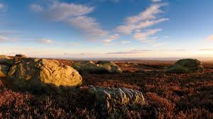
The second half of the walk emerges from the valleys and has excellent views.
This is not a difficult walk to navigate but it is to find the start.
The layby to start the walk is on a very quiet road off the B1253 heading south from Cowlam Grange. A finger sign opposite the layby marks the start.
Enter immediately in to the foot of one of the dry valleys. These are extraordinary, V-shaped with steep sides leading to the fields above. They formed roughly 15,000 years ago when the glaciers retreated.
The rivers left by the retreating glaciers flowed over the top of the frozen ground below creating the V shape of river erosion.
When the land below ceased to be frozen, the chalk bedrock allowed the water underground and the valleys became ‘dry’. Only after exceptionally wet weather do these valleys have streams.
After ¾ mile the path splits. Start with the left hand fork and head up the dry valley for a further one mile (follow the blue bridleway sign) to the church at Cowlam Manor.
Cowlam is a small hamlet, all that remains of a deserted medieval village, St Mary's church one of the better preserved buildings. It is believed that the Black Death caused the abandonment of the village.
Having explored the church, return along the path but before you arrive at the previous path junction (after the woods) take the left hand turn in to the dry valley of Phillip’s Slack (even more steep sided).
Continue north up the winding valley for 2/3 of a mile before a signpost directs you right straight up the side of the dale.
The path uphill becomes a track as it flattens and follows a hedge to a farm road. Turn right and head for Cottam Grange.
Continue past the manor in to a path across an open field (follow the power lines) before meeting a hedge and soon arriving at the medieval village of Cottam.
The Holy Trinity Church is a decrepit brick church in urgent need of salvation.
Start looking around the village, a series of lumps and bumps. Probably most impressive are the old field system shown as terraces across the valleys.
Turn left past the church and then soon right past the trees in front of Cottam House. On meeting a road turn left again, then instead of heading for the main road turn right at a signed path.
From here the views across the area and back to the dry valleys are excellent. It is the highest point of the walk at nearly 500 foot.
After crossing the highest land the track drops gradually to a second track. The next mile and a half of track is arrow straight, easy walking through farmland. It is easy and pleasant.
Towards the end of the track it drops sharply to the quiet road that is where the walk starts. Turn right back to your car.
Fact file:
Distance: Roughly 8 miles (includes 1 ½ mile extension to Cowlam Manor).
Height to Climb: 260m (850 feet)
Start: SE 973634. A lay by offers some parking for the walk.
Difficulty: Medium. The walk is very easy underfoot but certainly with the extension to Cowlam is of reasonable length and includes a steep climb.
Refreshments: The nearest pub is at Sledmere or a choice at Driffield. Both within 5 miles.
Be Prepared: The route description and sketch map only provide a guide to the walk. You must take out and be able to read a map (O/S Explorer 300) and in cloudy/misty conditions a compass. You must also wear the correct clothing and footwear for the outdoors. Whilst every effort is made to provide accurate information, walkers head out at their own risk.
Please observe the Countryside Code and park sensibly.
Comments